





 配送


Social Sensing and Big Data Computing for Disaster Mana 可代的詳細資訊
賣場滿300元出貨,請悉知!
廠家直发,歡迎咨詢,量大從優。
1、本店書籍由於是批量上架,正版全新書籍會在標題或商品頁說明;無說明默認為影印版或舊書,影印版內容與正版原文一致,圖片黑白,可能存在印刷模糊但不影響閱讀;舊書為正版7-9成新,存在筆記劃線等,介意者慎拍!
2、需要正版新書,請下單前咨詢客服確認,感謝您的理解和支持!
3、購買書如有外皮碰撞痕跡.因不影響讀閱內容,是不退換。除寄錯書籍可退換外(簡體書均為海外倉庫寄出難免有碰撞~請見諒~但我們會在包裝上做好防碰撞處理~請放心!)
4、本店書籍均為跨境運輸(走空運),當天發貨,運送時間約2周內送達;物流單號一周內上傳,不影響運輸,急單勿拍!
5、重量5公斤以內,走空運;超過5公斤走海快,物流需要轉宅配,比空運時間長2-3天,切換物流會提前與買家溝通。
6、離島地區(即金門、澎湖、馬祖等離島地區)請選擇宅配或離島配送;若選擇711或全家,下單前請咨詢客服運費。
7、本賣場提供免費尋書服務,發送ISBN號或書名+作者給客服查詢,有庫存會同步上架。
注意!本賣場是海外運輸,非質量問題不支持無理由退貨,請大大們閱讀後再下單,感謝。
書籍為正版書籍 ,部分絕版書籍,為舊書或者二手書籍,建議咨詢客服
1.書籍均為簡體正版書籍,大陸版社直接寄送。部分絕版書籍為二手二手書籍
2.貨物3天內安排寄送,到貨時間大概8~12天,有時間要求請及時聯繫。
3.圖書因物流運送且多為單冊包裝,偶有碰撞折損潮損,非無法閱讀均不可退貨,完美要求者請切勿下標。
4.大物件商品超過超區規格,需要下標宅配到付哦 。
5.可免費代尋書籍!店鋪每天上新歡迎關注!
6.收到商品有任何問題,歡迎咨詢,感謝~
開 本:18開
紙 張:輕型紙
包 裝:精裝
是否套裝:否
國際標準書號ISBN:9780367617653
所屬分類:圖書>英文原版書>健康與心理 Health, Mind & Body
Social Sensing and Big Data Computing for Disaster Management
作者: Li, Zhenlong
出版社: Routledge (2020年11月22日)
頁數: 192頁
語種: 英語
ISBN: 9780367617653
條形碼: 9780367617653
商品重量: 340.00g
商品尺寸: 24.61cm * 17.40cm * 1.12cm
編輯推薦
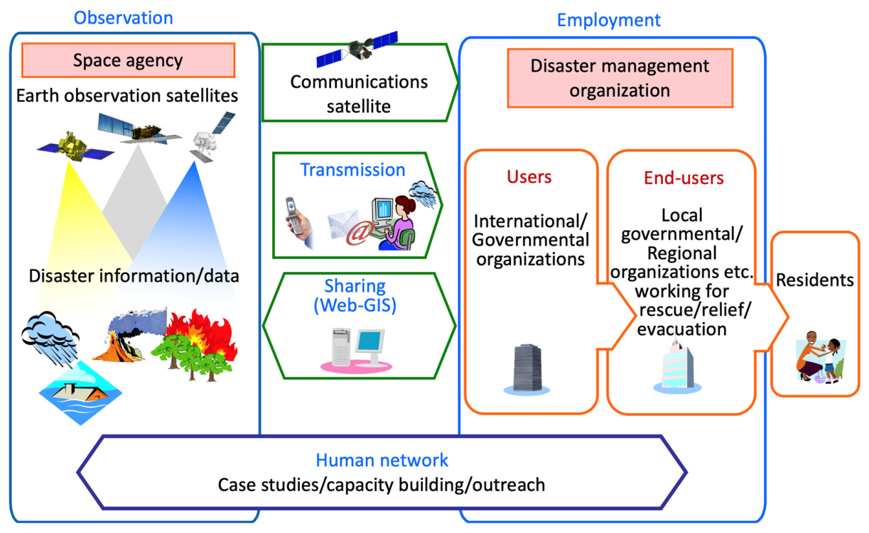
Social Sensing and Big Data Computing for Disaster Management captures recent advancements in leveraging social sensing and big data computing for supporting disaster management. Specifically, analysed within this book are some of the promises and pitfalls of social sensing data for disaster relevant information extraction, impact area assessment, population mapping, occurrence patterns, geographical disparities in social media use, and inclusion in larger decision support systems.
Traditional data collection methods such as remote sensing and field surveying often fail to offer timely information during or immediately following disaster events. Social sensing enables all citizens to become part of a large sensor network which is low cost, more comprehensive, and always broadcasting situational awareness information. However, data collected with social sensing is often massive, heterogeneous, noisy, and unreliable in some aspects. It comes in continuous streams, and often lacks geospatial reference information. Together, these issues represent a grand challenge toward fully leveraging social sensing for emergency management decision making under extreme duress. Meanwhile, big data computing methods and technologies such as high-performance computing, deep learning, and multi-source data fusion become critical components of using social sensing to understand the impact of and response to the disaster events in a timely fashion.
This book was originally published as a special issue of the International Journal of Digital Earth.
Biographical Note
Zhenlong Li is Associate Professor in the Department of Geography at the University of South Carolina, USA where he established and leads the Geoinformation and Big Data Research Laboratory. His primary research focuses on geospatial big data analytics, spatiotemporal analysis/modelling, and CyberGIS/GeoAI. By synthesizing advanced computing technologies, geospatial methods, and spatiotemporal principles, his research aims to advance knowledge discovery and decision making to support domain applications including disaster management, climate change, human mobilities, and public health.
Qunying Huang is Associate Professor in the Department of Geography at the University of Wisconsin-Madison, USA. Her fields of expertise include spatial computing, spatial data mining, and spatial data analytics. Dr. Huang\'s research bridges the gap between computer and information science (CIScience) and GIScience by generating new computational algorithms and methods to make sense of complex big spatial datasets obtained from both the physical sensing (e.g. remote sensing) and social (e.g. social media) sensing networks. The problem domains of her research are related to natural hazards and human mobility.
Christopher T. Emrich is Endowed Associate Professor of Environmental Science and Public Administration within the School of Public Administration and a founding member of the newly formed National Center for Integrated Coastal Research at the University of Central Florida (UCF Coastal), USA. His research/practical service includes applying geospatial technologies to emergency management planning and practice, long-term disaster recovery, and the intersection of social vulnerability and community resilience in the face of catastrophe.
商品備註・物品狀況:全新・最新關注時間:2026-09-21







暢銷商品排行榜



查看此商品的人也看了以下商品
-
 我的商店庫存: 395含稅1929元
-
 我的商店庫存: 375含稅735元
-
 我的商店庫存: 410含稅1614元
-
 我的商店庫存: 259含稅3556元
-
 我的商店庫存: 169含稅7607元
附近賣場的商品



顧客評論
推薦度 4.4分
目前有 144則評論。